FAST FACTS: SANTA MARIA, LAGUNA
Santa Maria, Laguna was classified as a barrio of Mabitac, Laguna. It was formerly known as 'Cabuoan' ('Kabuhuan' in Tagalog) and was proclaimed as a separate municipality in 1903. Mayor Rocelle Valdecantos Carolino is its current municipality head.
GEOGRAPHY
14° 2’ 0’’ longitude and 121°10’0’’ latitude
NW - Tanay, Rizal NE – Infanta, Quezon
E – Famy, Laguna
W – Rizal Province
S – Mabitac, Laguna
108.4 km2 (12841.5 hectares)
129 km away from Manila
33 km away from
Santa Cruz
Antipolo Sandy Clay and Loam
Composed of 25 barangays
(Urban: 7 Rural: 18)
DISTINCTIONS
4th class municipality
4th District of the Province of Laguna
Rice Granary of
Laguna
SOCIAL SERVICES
Health 8 (Health Centers)
1 (Medical
Clinic)
Education 27 (Public Schools)
1 (Private
School)
1:28
(Teacher-Student Ratio)
INFRASTRACTURE
Almost all roads
are paved
Water Supply: 12 barangays
Power Supply: 25 barangays served
TRANSPORTATION
Tricycle,
Motorcycle, Private Cars, Bus
LAND USE PROGRESS (1992-2013)
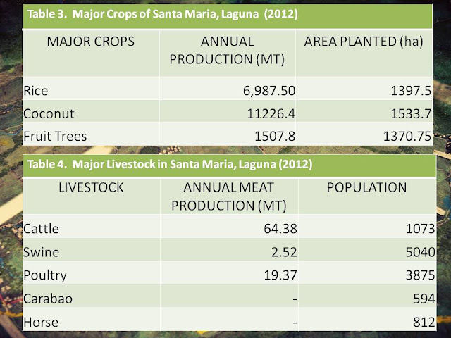
CROPS AND LIVESTOCK
Pujanes, Khristine Hope. "Changing Land Use Patterns and Settlement Planning
in Santa Maria, Laguna." Paper presented at College of Human Ecology, UPLB. 2012.


Comments
Post a Comment